Research interests
Research specialties:
Spatial statistics and quantitative spatial analysis
Spatial information science and GIS (Geographic Information Systems)
Medical and health geography
Neighborhood environments and human health
With advancements in information technologies including remote sensing, GPS, and ubiquitous computing, spatial data―data with locational information―have rapidly been growing in size, diversity, and available details. Spatial Information Science (or Geographic Information Science; GISci) deals with theoretical frameworks for effective and efficient acquisition, management, analysis, and representation of spatial data; my specialty is spatial analysis, that is, quantitative and statistical analysis of spatial data.
I have been interested in relationships between human health and living environments. This topic has a long research history, which could arguably be traced back to Hippocrates, an ancient Greek physician. Whereas natural environments such as climate and water are traditionally major foci in this field of research, a broader range of environments including micro-scale individual-level living environments have come to receive increasing attention as developed countries are facing new types of health concerns such as lifestyle-related illnesses and aging. My research aims at analyzing and understanding relationships between human health and living environments from the perspectives of spatial information science so as to contribute to development of healthier urban environments.
Keywords: spatial information science, GIS, spatial statistics, spatial analysis, space-time monitoring, spatial analysis on the network, medical/health geography, neighborhood living environments, obesity, physical activity, walkability, food environments, ...
Three main topics of my recent research are explained below.
(1) Neighborhood walkability and health of residents
Walkability is a coined word consisting of "walk" and "ability" and represents physical elements of urban environments that support walking, which is a physical activity that we can easily incorporate into our everyday life. The concept of walkability was emerged in conjunction with serious obesity problems faced in developed countries such as the United States. Since interventional and research efforts to promote healthy changes in personal lifestyles have resulted in very limited success so far, environmental approaches to the obesity problem are now receiving increasing attention. Walkable neighborhoods, for example, are hypothesized to promote walking among residents and thus help them achieve and/or keep healthy weight status. Healthy city planning aims at development of urban living environments that would help people live a healthier life (e.g., conducting more physical activity and making healthier food choices.) In Japan, while obesity is not so serious yet in comparison with other developed countries, we must be prepared for emerging health issues of the upcoming super-aging society. I believe that walkability would play an important role there to encourage the elderly to be more physically active and stay healthy. My current research involves development of walkability measures that fit Japanese cities (since the majority of prior work in this field focused on western cities) and empirical analysis of association between walkability and residents' health status.
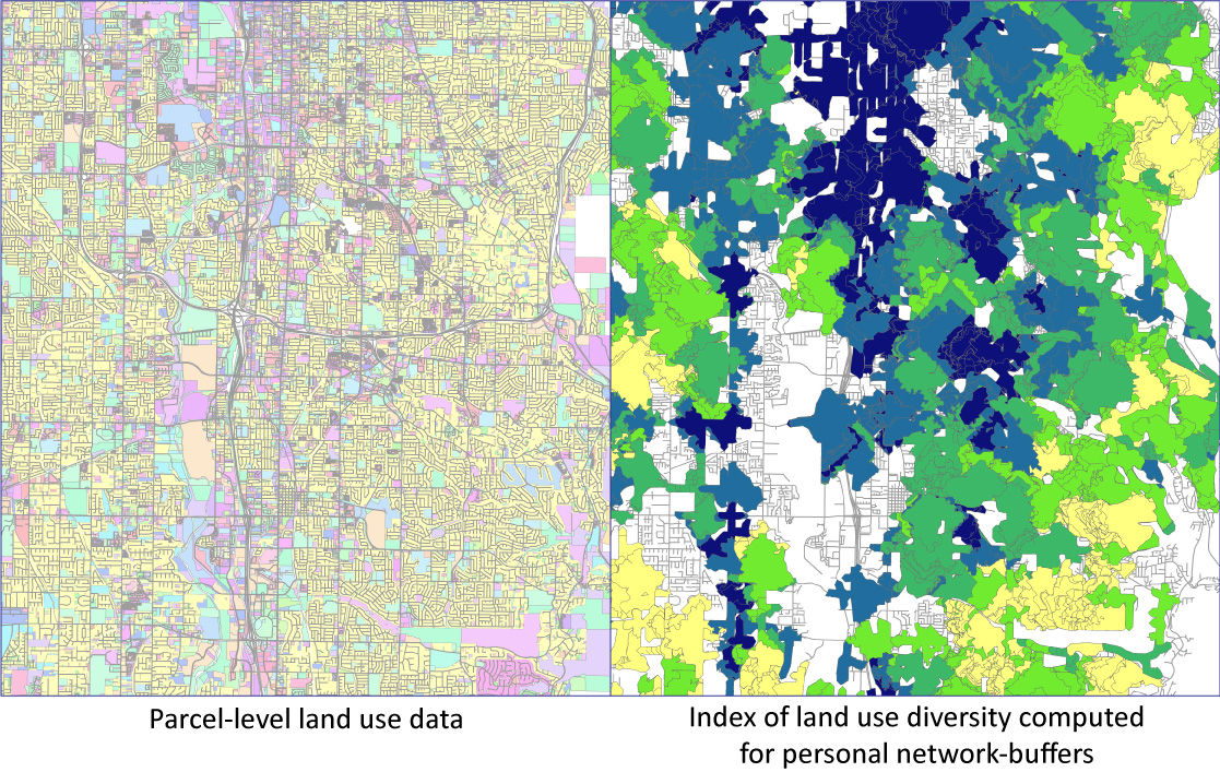
Land use diversity as a measure of neighborhood walkability.
(Data source: Utah Automated Geographic Reference Center)
(2) Detection of spatial patterns through statistical methodology
Spatial analysis starts with finding "interesting" spatial patterns in data. For example, when spatial distribution of a particular health problem exhibits patterns that cannot be explained by known risk factors at either individual or contextual level, it is implied that there may exist unknown spatial factors that relate to the health risk. I am particularly interested in development of spatial statistical methodology for pattern detection that explicitly takes into account human-built factors, for example, transportation networks.
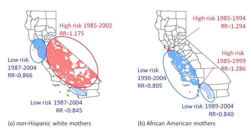
Space-time clusters of the risk of low birthweight in California, USA, 1984-2004.
(Data source: Center for Health Statistics, California Department of Health Services)
(3) Space-time monitoring to detect emerging spatial patterns
Thanks to state-of-the-art information acquisition technologies such as ubiquitous computing, spatial data with detailed spatial and temporal elements have increasingly been available almost in real time. Space-time monitoring using real-time detailed spatial data has great potential to investigate changes in spatial patterns as they emerge, which allows us to detect outbreaks of an infectious disease as quickly as possible, for instance. Space-time monitoring is one of the most expected research themes in the field of spatial analysis.
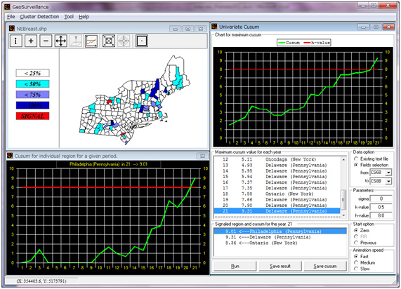
GeoSurveillance software developed with Dr. Peter Rogerson
in the Department of Geography, University at Buffalo.